
Climate Resiliency
on Block Island
Corn Neck Road and Town Beach Pavilion
Timeline
Living with Coastal Change on Block Island
A Timeline of Crescent Beach, Corn Neck Road and the Town Beach Pavilion
Pre-1880
Since the earliest human presence on Block Island, the beach has been a place of gathering, recreation, and connection. Indigenous communities, namely, the Manissean people, lived on and cared for the island long before European arrival, and the beach served as an important part of daily life. In 1524, Italian explorer Giovanni da Verrazzano sailed past the island and wrote that it was “well peopled, for we saw fires along the coast.” Over the centuries, storms, waves, and human activity have continually reshaped the shoreline, but the beach’s role as a host of community and gathering remains unchanged.


1880's-early 1900's
In the 1880s, the Town of New Shoreham built the Block Island Bathing Houses to serve a growing number of beach visitors. Located about 300 yards south of this site, the facility included a multi-use pavilion and changing rooms designed to be moved inland each winter. Long before "climate resilience" became a common term, island residents understood that the shoreline is always changing. By relocating buildings away from storms, flooding, and erosion, they adapted to natural coastal processes. The tradition of living with the dynamic Block Island coastline continues to inform resilient design and stewardship today.


September 1938
On September 21, 1938, the Great New England Hurricane struck Block Island as a Category 3 storm, with winds exceeding 100 mph, a powerful storm surge, and heavy surf. Homes, roads, harbor facilities, and fishing vessels across the island were severely damaged. Along the south end of Corn Neck Road, waves washed over the roadway, and the Bathing House sustained extensive damage. The storm revealed the power of the ocean—and the importance of rebuilding in ways that strengthen both the island and its coastline.


June 1954
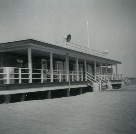
After decades of storms and coastal wear, the original Bathing House was replaced after the State of Rhode Island assumed management of Town Beach. A new one-story bathhouse built with durable redwood opened in 1954 in this location, offering modern amenities designed to serve generations of visitors. Later painted the iconic "State Beach Green," it became a beloved landmark—and a reminder that each new chapter on Block Island builds on lessons from the coast.


August 1954
Hurricane Carol struck Block Island on August 31, 1954, bringing sustained winds exceeding 100 mph, gusts reported as high as 135 mph, and a storm surge that reached up to 14 feet in some locations. The storm caused extensive damage across the island where powerful waves reshaped beaches, damaged infrastructure, and impacted coastal habitats. Although it had opened only months earlier, the new beach pavilion weathered the storm well, with surge waters flowing beneath the building, highlighting the importance of resilient design along the coast.


1960-1990
From the 1960s through the 1990s, Block Island experienced a relatively calm period with fewer major coastal storms. Block Island’s dunes recovered, tourism grew, and new investment shaped the shoreline. This period brought prosperity and a renewed connection to the coast - but the quiet years also masked ongoing vulnerability of sensitive coastal systems. As ever, the shoreline remained in motion, with beaches, dunes, and bluffs continuing to shift in response to natural coastal processes.


1989
When the aging State Beach pavilion was taken down in 1989, the community chose to preserve what mattered most: a place for connection, recreation, and shared memories along the shore. Construction delays resulted in two summers without a pavilion, but a new facility opened in 1991, solidifying the beach pavilion's role as a community landmark. Soon afterward, beach pavilion ownership and beach management returned to the Town of New Shoreham, and the beach was renamed in honor of Fred Benson, a cherished community figure.


1991
After decades without a major hurricane landfall, Hurricane Bob struck Block Island on August 19, 1991, bringing Category 2 destructive winds, storm surge, and beach erosion. Just two months later, the No-Name Storm—later known as the “Perfect Storm”—generated massive waves and coastal flooding along the New England coast. These two storms both breached Corn Neck Road at Settlers Rock, temporarily connecting the Atlantic Ocean with Sachem Pond—an uncommon event that highlighted the island’s vulnerability to coastal flooding and erosion. Together, these 1991 storms marked the return of severe coastal hazards to Block Island, and renewed awareness of the island's shoreline vulnerability.

October 2012
Superstorm Sandy reached Block Island on October 29, 2012, bringing powerful waves, storm surge, and coastal flooding that exposed the vulnerability of the island's shoreline infrastructure. Along Corn Neck Road, approximately 1,800 feet of roadway was heavily damaged or washed out by the storm, cutting off access to homes and businesses north of the breach. Emergency repairs rebuilt the road in the months that followed, but Sandy sparked new conversations about long-term resilience, dune restoration, and the future of one of Block Island's most important coastal corridors.


2013
In the wake of strong storms, the Town of New Shoreham completed the Block Island Harbors Sea Level Rise Adaptation Study in 2013. The study examined how rising seas, stronger coastal storms, and future flooding could affect critical infrastructure, including roads, ferry terminals, harbors, and public facilities. This marked one of the island's first comprehensive efforts to evaluate climate risks and identify strategies for adapting to a changing coastline.
.png)
2017

Recognizing the importance of Corn Neck Road as the island's primary north-south transportation corridor, the Town completed the Corn Neck Road Transportation Resiliency Planning Study in 2017. Prompted by damage from Superstorm Sandy, the study evaluated options to reduce erosion, flooding, and storm damage while maintaining emergency access, evacuation routes, and connections between the northern part of the island and Old Harbor. Recommendations laid the groundwork for many of the resilience and dune restoration projects that continue today.
Early 2020's
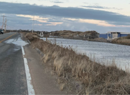
Recent years have brought a renewed period of severe weather to Block Island, intensified by the warming climate and rising sea levels. Powerful nor’easters, winter blizzards, and heavy rainfall during storms have produced storm surge, beach overwash, and flooding along the island's eastern shoreline. Waves have periodically crossed the beach and dunes, while flooding has affected parking areas and portions of Corn Neck Road. Nature is offering clues about how this shoreline responds to storms. Each year, sand naturally accumulates along the ocean side of the pavilion, forming a dune that must be cleared before the summer season. This recurring process reflects the coastline's tendency to build natural protective barriers in this location—barriers that help absorb wave energy, reduce flooding, and protect inland areas.


2023-2028

Resilient Corn Neck Road for Future Generations
Today, our island must forge a new approach to resilience along Corn Neck Road, one that stewards both this fragile, dynamic coastal system and the critical infrastructure of the community's Town Beach pavilion.
With support from the Rhode Island Infrastructure Bank and the National Fish and Wildlife Foundation, the Town has assessed the vulnerability of Corn Neck Road to coastal flooding resulting from projected sea level rise of three to six and a half feet by 2100, and more intense and frequent storms caused by atmospheric warming. Since 2023, the Town has also developed designs for permitting to improve stormwater management in Scotch Beach parking area and to mitigate the negative impacts to the dunes from the three paths between Scotch and Town beaches, as well as conceptual designs for removing and rebuilding the beach pavilion to allow the dunes at Town Beach to be rebuilt as a natural barrier to storm surge. Together, these efforts are building a framework and feeding into Town planning for a more resilient shoreline - one that protects critical infrastructure by strengthening the ecological systems that serve as natural barriers to flooding.
In 2026, the Town expects to receive additional funding from the National Fish and Wildlife Foundation, and through the RI Department of Environmental Management (DEM), for resilience projects along Corn Neck Road. This next phase focuses on the Beach Pavilion, adjacent salt marshes, and the southern end of Corn Neck Road. Design and permitting will establish a pathway toward future construction funding, creating opportunities to invest in dunes, wetlands, parking lot drainage, public access, and resilient built infrastructure—one connected coastal system with the capacity for change. With continued research, community input, planning and public investment (grant support and tax dollars), Corn Neck Road can become a model living coastline that absorbs storms, recovers from disturbance, supports habitat, and continues both serving the community over time and strengthening the vulnerable ecological systems of the Island we so cherish.
Town of New Shoreham's Coastal Resilience Commitee
The Nature Conservancy's Climate Resilience on BI page
GZA GeoEnvironmental's Protect Corn Neck Project page
For more information and additional resources on building resilience and more, see our resource library.